Accompanying a New York Times review of a new book by Ali Alatas, "the former longtime foreign minister and ambassador to the United Nations", is a map showing (purportedly) East Timor, the subject of the book and the article:
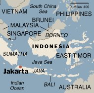
Note the location of the state, which somehow has been pushed up toward Sulawesi. Now, here is the actual map of the region, from another Web site:
How could they get it so wrong?

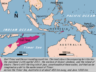
Note the location of the state, which somehow has been pushed up toward Sulawesi. Now, here is the actual map of the region, from another Web site:

How could they get it so wrong?
No comments:
Post a Comment